
26-27 June 2012 Bogor, INDONESIA
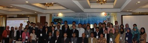
ADRC collaborated with LAPAN organizing the workshop entitled "ASEAN Cooperation Project on Utilization of Satellite Images for Disaster Risk Management". This workshop is aimed at reporting all activities in this project. The delegates from several member states of ASEAN: Brunei Darussalam, Cambodia, Myanmar, LAO PDR, Thailand, Vietnam, and Indonesia were involved in this workshop. This project is funded by the JAPAN-ASEAN Integration Fund (JAIF). The main objective of the project is to increase the awareness and develop necessary skills in using satellite data/images of government officers in disaster management agencies, mapping agencies, space agencies, and other related agencies of ASEAN member countries who are engaged in disaster mitigation and risk management activities. These objectives are achieved through appropriate capacity building programs including seminars, workshops and hands-on training programs conducted locally in each of the member counties and regional workshop to share the knowledge and experiences among all the members. This workshop was held on June 26-27, 2012 at Salak Hotel, Bogor - Indonesia.
The workshop was attended by 76 participants from government and government-related organizations engaged in disaster mitigation and development activities and keen to incorporate remote sensing techniques in their present day needs. The workshop began with a welcome address by Mr. Kiyoshi Natori executive director (ADRC). Organization of the program divided into opening session, presentation of ASEAN countries, and presentation of external experts and local agencies. The resource personnel were from ADRC-Japan, JAXA-Japan, AIT-Thailand, ASEAN-SCOSA Secretariat, AHA Center, and local institutions (LAPAN, BNPB).
(2012/07/18 13:40)