Background on Disaster Management in Vietnam
1 - Background information
| FACT | FIGURE |
|---|---|
| Official Name | The Socialist Republic of Vietnam |
| Area | 331,690 km2 |
| Population | 78.45 million (1 April 1999) |
| Population Density | 226 person/km2 |
| Percentage of Urban Area | 79.2% |
| Gross Domestic Product | 26.193 billion $US |
| Per Capital Income | 335 $US |
Geographcial location
of Vietnam
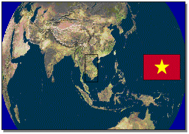
Vietnam is the 2nd largest country in South East Asia after Indonesia. It is divided into 3 regions: and
- Northern Vietnam consisting of
provinces bordering China and those that lie in the Red River Delta; and
- Central Vietnam
with provinces lying between the central coast and the 1,600 km-long
Truong Son mountain range; and
- Southern Vietnam
which includes Ho Chi Minh City, the few provinces east of the city, and
the rice-rich provinces of the Mekong River Delta.
The
south of Vietnam mainly consists of plains. 2 major rivers, the Mekong River in
the south and the Red River (Hong) in the north each form deltas of
considerable size before entering the South China Sea. The Red River also runs
through Hanoi, the capital city.
Fig. 2 Topographical map of Vietnam

Although the country is located in the tropics, the climate is tropical only in central and southern Vietnam, with warm and humid weatherall year round (22-35oC). In the north, there is a distinct winter season due to cold inland winds. Usually, the winter is also the dry season for the entire country, but the rains are highly unpredictable owing to the influence of several monsoons.
2 - Classsification
Viet
Nam is one of the most disaster-prone countries in the world. The table below describes the relative frequency of disaster phenomena in Viet Nam and it is clear, that most of the disasters are direct or indirectly water related (or caused by the absence of it).
Viet Nam's
near-uniformly high rainfall should provide sufficient water for most of its needs.
Water is the one of the most crucial resources of the people of Vietnam. Much of what
constitutes Vietnamese society emerged from centuries of struggle to capture
annual rains to irrigate paddy rice. By no coincidence the major Vietnamese
population centers are on the banks of Red River, Perfume and Cuu Long rivers.
However,
water-related disasters are the most serious in Viet Nam and cause regular and
substantial suffering, loss of life and economic damage.
The
water coming all within the space of a few short months, the monsoon rains
saturate the earth, flood the rivers and threatened the broad plains of the
river deltas. Coupled with seasonal typhoons that batter the coasts before
moving inland, flooding is annual occurrence in Vietnam.
On average, 4 to 6 typhoons reach Viet Nam each year, and hundreds of people are killed. It is anticipated that the number of heavy storms and typhoons to hit
Viet Nam will increase both in number and intensity with global warming.
Table 2 - Relative Frequency of Disaster Hazards in Viet Nam
| HIGH | MEDIUM | LOW |
|---|---|---|
| Flood | Hail & Rain | Earthquarke |
| Typhoon | Drought | Lasndslide |
| Inundation | Erosion Fire Deforestatation | Sea Water Intrusion |
The
worst damage is caused by floods, particularly when accompanied by typhoons.Typhoons raise sea levels many meters and cause storm surges up estuaries,inundating valuable cropland. Typhoons destroy buildings with their
high-velocity winds, and generate waves, which can damage sea dykes protectingcoastal land holdings. The torrential rains, which accompany typhoons, can cause flash floods, which come upon settlements unawares, and regularly submerge low-lying areas.

The runoff from these typhonic rains, when added to rivers already swollen by
monsoon rains, creates floods which endanger river dykes and threaten to
devastate millions of households.
One
reason that water disasters are so serious is that most of the population lives
in areas susceptible to flooding. This is because Viet Nam has developed as a
nation by exploiting the low-lying river deltas and coastal lands for wet-rice
agriculture. Thus both the broad
Red River and Mekong Deltas and the narrow connecting coastal strip of the
country are prone to flooding from monsoon rains and typhoon storms. Further, the remaining three-quarters
of the country are mountainous and suffer from flash flooding. As a result, over 70% of the population
of Viet Nam is at risk of water disasters.

In
addition, rivers whose flood plains are protected by a system of dykes, which
confine floodwaters, have higher flood water levels than they had formerly. At
present, during the wettest months, the Red River near Hanoi can have water
levels five or six meters above ground level, whereas 1,000 years ago waters
only rose 2 to 3 meters above ground level. The river and coastal dyke systems of Viet Nam are centuries old and suffer from piping, slides and local collapse, in spite of the strengthening and repair work done by hundreds of thousands of people mobilized every flood season.
Over
the past 25 years, more than 13,000 people have been killed by natural
disasters. A tropical depression off the coast of Thanh Hoa in 1996 caught
thousand of fisherman at sea; over 600 lost their lives. In the same year, in the mountain province of Lai Chau, the hamlet of Lo Le was literally washed off
the map by flash flood, 89 people were killed. In 1997 typhoon Linda became the worst natural disaster in living memory. Skirting the tip of southern Vietnam, this clamed the death toll of over 3,000 people and more than $US 400 million
in damages.
Finally,
non water-related disasters in Vietnam, while fewer commons than water
disasters, are having an ever-greater impact on the country. Vietnam's
remarkable socio-economic and industrial development over the last ten years
has increased the risk of technological accidents; industrialization and
population growth have put severe pressure on Vietnam's forests; climate change
has led for the first time to drought in certain areas, thereby increasing risk
of forest fire as well.
3 - Institutional
aspect in disaster management
Vietnam
has well-developed institutional, political and social structures in the region
for mitigating water disasters. These structures have evolved over centuries as
the Vietnamese population developed the agricultural potential of its great
river deltas.
Over
more than 2000 years, the Vietnamese people have developed elaborated systems
to counter the threat of water disasters. Physically, this system include river
dikes, sea dikes and flood diversion and control schemes consisting of dams,
weirs, sluices and other facilities.
Started
in 13th century, the Imperial Court had appointed two mandarins, one
to look after the dykes and other to look after the irrigation systems. These mandarins
then delegated other mandarins to look after the dikes and irrigation systems
at different levels right down to the level of village. The essential form of
the administrative arrangements set out then can still be discerned today.
Such
administrative system continually maintained and developed since then up to the
end of 19th century when French came.
In
French colonial period, the disaster prevention activities are under the
IndochinaÅfs Public Work Authority of French. In fact, the activities are mainly
concentrate to the water resources planning and constructions of some hydraulic
works serving for some vital agriculture areas that French has great interest.
Little effort was paid for the construction of disaster prevention
infrastructures such as dikes, flood prevention structures.
After
the independent in 1945, the government established the Committee for Flood
fighting and Dike management from the central level to local levels. These
organizations have acted effectively to cope with disasters. However,
continuous wars render much effort of people in this field and worsening the
consequences of disasters.
After
the great flood in 1971, the much effort has given to the disaster management
activities. In 1994 strategy and action plan for mitigating water-related
disasters was adopted. Efforts are currently underway for the preparation of
strategy for mitigating all kind disasters of the country.
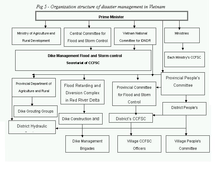
Institutionally,
Vietnam has developed complex systems to cope with the threat of water
disasters. At the local level, most provinces have active committees for flood
and storm control. This is paralleled at the national level with Central
Committee for Flood and Storm Control which includes representatives from
different ministries such as Rural development, Construction and
Transportation, Hydro-meteorological Agency and Arm Forces.
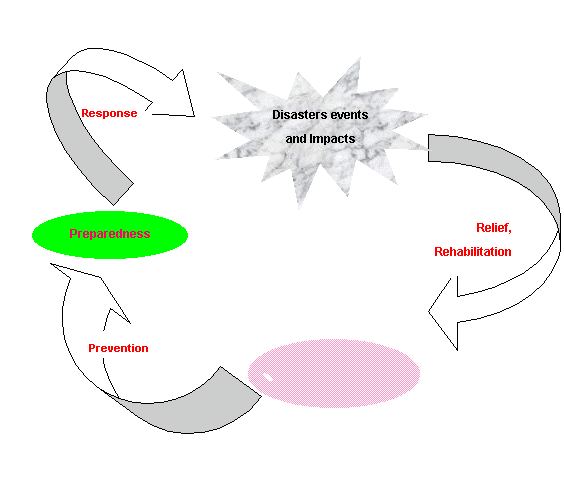
4 - Toward a better future
Natural
disasters such as those discussed above result form the normal interaction of
nature and the environment. Often these events become disasters because of
inappropriate patterns of human development. Forests are cut down, increasing
the speed of rainfall runoff and choking waterways with eroded silt. Flood
plains are encroached upon and built up with houses, factories, and hotels.
Mangrove forests, coastal marshes and sand dunes are torn away to make room for
more development, eliminating these natural defenses against high waves and
typhoons.
The overall goal for Vietnam in the future must be to ensure that
pattern of development are suitable. Natural disaster by their nature are never
fully predictable, efforts to reduce pressures of development and population
growth on to sensitive lands can help mitigate the impact of natural disasters.
In the future our action in disaster management will concentrate
on:
- Foster the
sustainable development of areas
prone to water disasters;
- Reduce the loss
of life injury, trauma and social disturbance caused by disaster to an
acceptable amount.
- Increase the
economic benefits from the use of areas prone to disasters.
- To improve the
and sustain the environment