Protection from Floods and Drought-Providing Safety Every Day
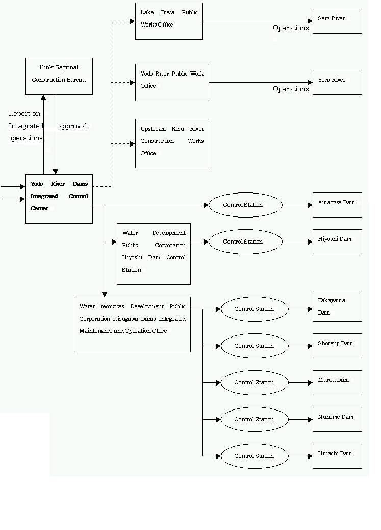
Source: Kinki Regional Construction Bureau
Yodo River Dams Integrated Control Center
Protection from water (Flood control in the Yodo River Basin)
The oldest flood control works in Japan date back to the time of the Emperor Nintoku (about 320 A.D.I.). Many such flood control works have been performed since then, such as the separation of Ogura Pond and the Uji River, the construction of the Bunrokutsumi (Bunroku Dike) by Hideyoshi Toyotomi in the 16th century, and the Yamato River redirection works during the first part of the 18th century. In the Meiji period, western techniques were introduced in Japan by De Lekay, an engineer from Holland, Tadao Okino and others, which brought about the start of full fledged flood control waterworks and reformed the Yodo River into a modern waterway.
Then in 1953, unprecedented floods caused by Typhoon no. 13 sparked the formation of the Basic Yodo River System Improvement Plan, employing a series of dams along the rivers. There were also improvement and construction works performed on the Seta River Weir (March 1961), the Amagase Dam (November 1964) and the Takayama Dam (August 1969). In 1959, Typhoon No.15 led to the construction of the Shorenji Dam (March 1974).
However, damage due to the floods persisted. This, along with the population increase and the concentration of population and industries within the potential floods area brought about the need to increase safety by broad margin, leading to the revision of the Yodo River System Basic Publics Works Plan in March of 1971. Based on the probability ratio for flooding, this plan called for the establishment of an auxiliary standard point, base system in each of the various districts according to the priority of needs.
At the standard point base at Hirakata on the main stream of the Yodo River, a simulation predicting the probability of the worst flood stage occurring once in the 200-year period was conducted. The results, considered along with a variety of flood patterns, led to the implementation of a basic high water quantity of flow of 17,000 m3/s and a planned high water quantity of flow of 12,000 m3/s.
- Basic Construction Works Plan:
- Based on the River Act and including plans for each river system, this plan provides for river safety, utilization and basic construction policies.
- Auxiliary standard point base system:
- This system includes the use of auxiliary standard point bases at Kamo and Hazukashi in addition to the base at Hirakata for the compilation of flood probability ratios.
- Flood stage once in a 200-year period:
- Based on a calculated rainfall of 302 mm for two days in the river basin.
- Basic High Water quantity of flow:
- The quantity of flow with no flow control facilities, such as dams, etc.
- Planned high water quantity of flow:
- The quantity of flow when flow control facilities, such as dams, etc., function as planned.
Water Utilization
The Yodo River Basin, including Japan biggest lake, Lake Biwa, has three sub catchment areas with unique geological and weather characteristics. A high quantity of flow occurs in the Lake Biwa, Katsura River, and the Kizu River catchment areas, respectively, during the snowy, monsoon, and typhoon seasons, but the river system is relatively stable. Many water utilization works related to Lake Biwa have been constructed in the past, such as JapanÅfs first general hydroelectric power plant, the Keage Electric Power Plant (completed in 1980). The yearly total quantity of flow in the Yodo River is about 8.7 billion-m3 . From 1985 to 1994, the high quantity of flow was 254.0 m3/s, the average quantity of flow was 223 m3/s, and in periods of water shortage the quantity of flow was 94.8-m3/s . Furthermore, the ensured quantity of flow at Yodo River junction point was 186.5 m3/s during the seasonal irrigation period and 140,000ha of land were irrigated. Approximately 13.5 million people (about 60% of the Kinki area population) utilize the basinÅfs tap water in the Keihanshin district. However, water use restrictions were imposed for a long period due to unprecedented droughts in 1984 and 1994. In the future, it is expected that there will be an even larger demand for water, calling for a stable water supply and appropriate water management.
Water EnvironmentThe biological oxygen demand (BOD) water pollution values showed a sudden increase after 1955, and in the 1964 the highest BOD value shown at the standard base point in Hirakata was 9.2-mg/l. In 1989 this value fell to 2.9-mg/l, and, even furthers by 1993 to 2.3-mg/l, due to water discharge standards and sewer installations. Water quality in the three tributaries of the Yodo River varies due to the different industries prominent in the sub-catchment areas. In the Katsura River catchment basin, residential and industrial discharge water from lower half of Kyoto runs into Katsura River. The standard base point at Miyamae Bridge showed a pollution increase in 1969 with a BOD value of 23.4-mg/l. At present, water purification works are being performed in facility erected along the river.
Influenced by the water running from Lake Biwa, the Uji River water quality is relatively stables (BOD of about 2.0-mg/l environmental standard of 3.0 mg/l) at Miyuki Bridge. However, water smelling of mold and abnormal incidents of plankton outbreaks due to nutrient enrichment has occurred.
At Miyuki Bridge on the Kizu River r, the BOD was 1.4 mg/l in the 1993 (environment standard of 2.0 mg/l), the best in the basin, but it is expected that development in the Keihana Hills will call for further efforts to maintain environmental standards in the future.
At present, automatic water purity observation equipment (measuring water temperature, pH, pollution, DO, anmonia, chemical oxygen demand (cod), etc.) has been installed along each river, and telemetry equipment sends these values to the center for daily observation.
Integrated Control of the Yodo River DamsThere are 13million users of the basinÅfs water, and 80% percent of the 10.63 million people living there are in the hypothetical flood zone, showing the importance of the flood control and water supply replenishment operations. These operations are conducted at nine facilities: the Seta River Weir, the Amagase Dam, and the Yodo River Weir, along the Yodo River proper, and the Takayama Dam, Shorenji Dam, Murou Dam, Nunome Dam, Hiyoshi Dam, and the Hinachi Dam, in the upper reaches of the Yodo River Basin.
The Yodo River Dams integrated Control Center performs integrated management of the running water in the basin, accumulating data on the amount of rainfall, water level, etc., and disseminating it to the appropriate offices and the facilities. When there is danger of flooding, input and discharge flow data of the dams in the system and the water level at the various is used to perform predictive calculations are issued to the dam control centers. During low water periods, extended period flow predictions are performed for each dam group, providing for efficient water supply replenishment operations.
Controlling "Irregular Water Flow" (Administration of the Water Flow in the Yodo River Basin)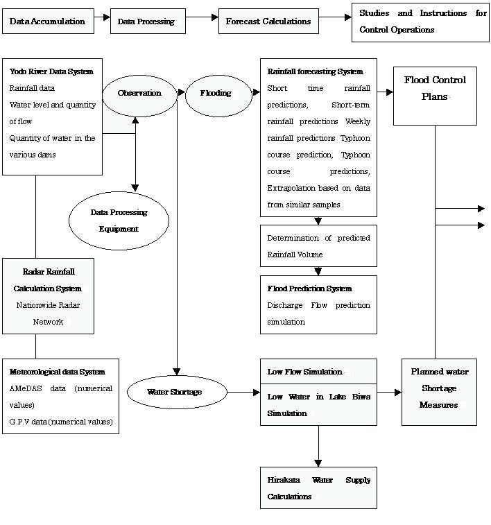
continue...
Yodo River Flood Forecasts
Disastrous floods have beset the Yodo River Basin time and time again in the past. In order to keep damage down to the lowest possible level, the chief of the Kinki Regional Construction Bureau and the head of the meteorological observatory in the Osaka district have cooperated to provide flood-forecast announcements. The information related to the weather situation is provided by Osaka district meteorological observatory. The related to running water is provided by the Kinki Regional Construction Bureau, with the Yodo River-Yamato River Flood Forecasting Liaison Association providing the required infrastructure. The Yodo River Dams Integrated Control Center employs a computerized calculation system to conduct water level and water flow predictions and increase the speed and accuracy of all floods control management and forecasting operations.
Bountiful Waterways, Supporting the Basic Fabric of Life and Society (A Summary of the Yodo River Basin)The 75-km long of Yodo River system, located in the central part of the Kinki Region, is a huge river system with a catchment area of 8,240 km2. Flowing south out of its source in the biggest lake in Japan, Lake Biwa, First as the Seta River and then the Uji River, it is then joined the Kizu River and the Katsura River near the border between Kyoto and Osaka Prefectures. This arterial waterways runs through the heartland of the Kinki region and empties into the Osaka Gulf.
The catchment area has an average yearly rainfall of 1,600 mm, with heavy rains both the rainy season, which is from June to July, and the typhoon season, from September to October. There have been both heavy floods and periods of drought in the past. However, mainly due to the large storage capacity of Lake Biwa, 27.5 billion m3, it can be said that the river conditions are stable.
Looking at the area in a geographical sense, the upper reaches of the Katsura River and the southern part of the Kizu River are enclosed by the mountain districts of Tanba and Takami, respectively. There are also mountainous districts around Lake Biwa, with Ibuki Mountains in the northeast, the Suzuka Mountain Range in the east, the Hira Mountains to the west, and the Ikoma Mountains around the southern part of the Yodo River. There are metropolitan areas spread throughout this river basin, Osaka, Kameoka, and Otsu, to mention a few, and thus the Yodo River basin forms the center of the districts base for the development and expansion of the Kinki region.